Nature’s Gifts to Our Bluff Lands: Limestone & Loess

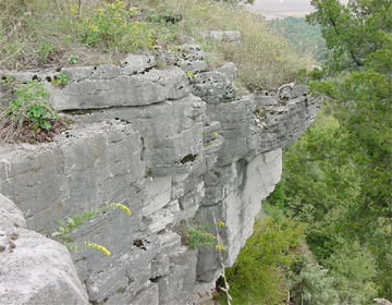
Loess soil, a geological gift, clings to limestone bluffs and makes possible our distinctive hill prairies. Photo courtesy Debbie Newman, Illinois Nature Preserves Commission.
How curious, even paradoxical, that Euro-Americans, the great landscape transformers who fashioned farms from forests, bistros on beaches and Disneylands in deserts, have for centuries continued to turn to nature’s landscapes for inspiration.
So much of our venerated poetry, prose, music, art, even today’s digital fantasy gamescapes, reflect a yearning to somehow recapture and return to a world of non-human touched, undefiled “nature.” We surround ourselves with touchstones of nature: automobiles named for inspirational animals, displaced landscapes remembered only as names of suburban developments, or, “I think that I shall never see / A poem lovely as a tree…” as Joyce Kilmer wrote in 1913. Where does nature, landscape and humanscape, overlap?
The well-known words of an Anglican hymn “rock of ages, cleft for me, let me hide myself in thee” were written in praise of a rock outcropping that provided shelter from a sudden thunderstorm during a summer afternoon hike an Anglican minister / poet had taken in Great Britain. But for the questioner who seeks the whys and hows of our bluff land’s natural landscape, the theological promise of the rock of ages is subsumed to inquiries about the age of rocks.
Our bluff lands corridor is anchored in earth’s ancient history. Only two miles beneath our feet – about the same distance as the short drive from the Salt Lick Point trailhead to the White Rock Nature Preserve parking area — lies metamorphic, basement rock associated with earth’s first fiery crust formation. About 600 million years ago, earth’s huge but thin continental plates rifted and began to migrate, separating into what we know as continents.
Along for the ride on the North American shelf, our region ended up beneath a warm, equatorial sea for 450 million years. In a process no different from current coral reef building, shelled, dead marine life built upon our metamorphic basement beginnings. Slowly, slowly, layer upon layer of stratified, sedimentary rock formed from the remains of corals. Marine fossils can still be found in rock pieces and demonstrate our oceanic heritage: the nearly two-mile thick mostly limestone overlayment that began to define our unique natural history.

The soluble limestone of our region also forms caves. This photo, taken near the entrance of Fogelpole Cave, is part of a new effort, led by Clifftop, to re-map this cave system using modern technology. Some of the mapping crew's gear is shown. Photo courtesy Chad McCain.
By 144 million years ago, continental migration reached today’s limits and Illinois and Monroe County came to rest where we now are. But it still was a much different world. The Gulf of Mexico extended northward and inland as far as Cairo, and the Mississippi River and floodplain in our county was a wide, deep, trough-like embayment flowing into the sea immediately to our south.
Our fiery and watery beginnings gave way to another geological stage in the formation of our bluff lands – ice. From 1.6 million to 10,000 years ago, Illinois underwent several periods of glaciation during which much of the state was covered by massive lobes of ice. The ancient course of the Mississippi River, near Grafton, was diverted eastward to accommodate glacial melt water. Throughout Illinois glaciers carved out the dulling, flat-as-a-pan topography associated with the Prairie State.
But, and extremely important to our bluff landscape, the most recent glaciers stopped just short of our area, gifting us the elevated, upland plateau, called the Salem Plateau, that we call home today. Our area received yet another distinct geologic gift by virtue of being at the edge of the ice.
During the periods of glaciation, large volumes of melt water flowed from the edges of ice fields during summers. The melt water carried tiny particulate matter scoured up by glacial movement over the underlying earth. Much of the sediment particulate was fine, silt-sized material, commonly and descriptively called rock flour. In winters, when glaciers refroze and outwash plains dried, howling winds pouring down from the glacial ice fields picked up and carried the rock flour in huge dust storms. Much of the silt fell out and blanketed our area. The resulting deposits, known as loess, created the 30 to 60 foot thick topsoil especially associated with the bluff land corridor. Our hill prairie soils still cling to the edges of the limestone escarpments that, as true rocks of ages, received and held the rock flour that, in the great course of time would become a wealth of grasses and plants in flower.
Probably no other type of rock can match limestone’s many uses. It provides lime for cement and many other industrial applications. Limestone is used as a soil sweetener for agriculture and gardening, an aggregate for road building and other construction needs, and as an ornamental facing stone for buildings. It also serves as an ingredient for soaps, cosmetics, paint, and — believe it or not — bubble gum.
If left to its own devices, limestone has a way of expressing its unique attributes, and, in our neck of the woods, has contributed to one of the most secretive and distinctive landscapes in Illinois — karst.

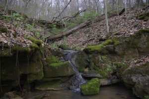
Springs, sinking streams, and sinkholes all are part of our bluff land's karst terrane. Photo courtesy Pen DauBach, Clifftop.
Karst comes into being in regions underlain by a substantial quantity of carbonate (limestone) rocks and where there is ample rainfall. The rainwater, rendered slightly acidic by the carbon dioxide in the atmosphere, seeps into the ground and dissolves sections of the alkaline limestone. Solution cavities form best where the limestone has vertical joints and where horizontal fissures exist between strata.
The motion of water and dissolution of limestone were only the starting point for the formation of subterranean tunnels, conduits and caverns. In a still on-going process, our bluff lands corridor now boasts the largest concentration of sinkholes, sinkhole ponds, sinking streams, and major cave systems in the state, all characteristic of karst terrain.
If you are interested in learning more about the geology and the sheer dynamics of the bluff lands corridor, Clifftop is hosting a seminar on the subject on Saturday, August 2nd, from 1 to 3 PM, at the Monroe County Annex Building, 901 Illinois Avenue, in Waterloo. Sam Panno, long-time geologist with the Illinois State Geologic Survey, will conduct the seminar. The talk is free and open to the public. Please pre-register at clifftop@htc.net or 618-458-4674 by July 30th if you would like to attend.
CLIFFTOP, a local nonprofit organization, is focused on preserving and protecting area bluff lands.
A version of this article appeared in the 18 July 2014 edition of the Monroe County Independent.
© 2014 all content rights reserved Clifftop NFP
Comments are currently closed.
